Ibiza Maps and Orientation
(Ibiza, Balearic Islands, Spain)
The Spanish island of Ibiza resides within the Mediterranean Sea, being the third-biggest of all the Balearic Islands, after only
Mallorca and
Menorca. Together with Formentera, Ibiza is part of the Pine Islands (Pityuses), a sub-archipelago based on the western side of the Balearics.
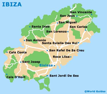
Prominent locations on the island include the capital - Ibiza Town (Eivissa), San Antonio (Sant Antoni) de Portmany and Santa Eularia des Riu. Marking the highest point on Ibiza is the mountain named Sa Talaiassa, which sits on the south-westerly side of the island and measures at just over 470 metres / 1,540 feet.
Maps and Orientation of the City
Within Eivissa, D'Alt Villa serves as the historic walled town, enjoying an elevated hilltop setting and some superb views. Nearby, in the direction of the harbour, Sa Penya is an interesting district, comprising narrow roads and alleys, countless whitewashed buildings, and a wealth of traditional shopping and Spanish-themed dining opportunities.
The Passeig de Vara de Rey is a notable promenade, which connects Avinguda d'Espanya with Sa Penya. If you are hiring your own set of wheels for the duration of your holiday and feel the need for maps of the island, then check out the tourist office on the Passeig des Moll, or alternatively the tourism outlet at Ibiza Airport.
Useful distances, directions and travel times from Ibiza Town are as follows:
- Barri Ca Na Negreta - 5 km / 3 miles (ten minutes, north)
- Cala Llonga - 16 km / 10 miles (25 minutes, north-east)
- Can Fornet - 7 km / 4 miles (12 minutes, north-east)
- Roca Llisa - 11 km / 7 miles (18 minutes, east)
- Sant Agusti des Vedra - 18 km / 11 miles (30 minutes, north-west)
- Sant Antonio de Portmany - 16 km / 10 miles (25 minutes, north)
- Sant Francesc de s'Estany - 7 km / 4 miles (ten minutes, south-west)
- Sant Joan de Labritja - 23 km / 14 miles (40 minutes, north-east)
- Sant Josep de sa Talaia - 14 km / 9 miles (20 minutes, west)
- Sant Llorenc de Balafia - 17 km / 11 miles (30 minutes, north)
- Sant Rafael de Sa Creu - 9 km / 6 miles (15 minutes, north)
- Santa Eularia des Riu - 15 km / 9 miles (25 minutes, north-east)
- Santa Gertrudis de Fruitera - 12 km / 7 miles (18 minutes, north)
- Talamanca - 1.5 km / 1 mile (three minutes, east)
- Vista Alegre - 16 km / 10 miles (25 minutes, west)
Map of Spain

Map of Ibiza